The Urungach lakes: two mountain lakes above the Pskem
An emerald lower lake and a larger upper lake in a side gorge of the Pskem valley. How to get there, how hard the trail is and when the water is at its most striking colour.
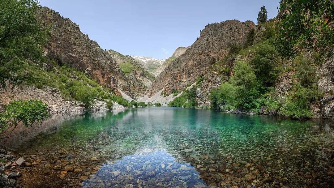
Urungach is one of those trips where the photos look edited afterwards. Two lakes lie one above the other in a narrow side gorge of the Pskem valley, and their water shifts from turquoise to deep emerald depending on the light and the season. They are harder to reach than Charvak but easier than the high lakes further up the Pskem. It is a good first step for anyone who wants to move from easy walks to real mountains.
What these lakes are
The Urungach lakes formed when rockfalls dammed the bed of a mountain stream. That explains their shape: long and narrow, with steep banks and fallen trees at the water's edge.
- The lower lake is smaller, with a particularly rich green colour. It is closer, and many people stop here.
- The upper lake is larger and calmer, ringed by forest and rock. A steep trail leads up to it from the lower lake.
Juniper, maple, hawthorn and wild fruit trees grow around them. The gorge is part of the Ugam-Chatkal National Park, so the same rules apply as in the rest of the park.
Getting there
The journey has three stages.
- Tashkent to Chirchik. About 35 km, half an hour to an hour depending on traffic. The easy option is a seat in a shared car on Tashkent — Chirchik, with trips leaving from the morning.
- Chirchik to the lower Pskem. The road continues past Charvak, through Bogustan and up the Pskem valley. This stretch is done by car with a local driver; arranging a transfer is easiest in Chirchik or at the reservoir.
- The Urungach gorge. From the road in the Pskem valley, a dirt track and trail lead up the gorge to the lakes. Part of the way is sometimes driven in a 4x4, the rest is on foot.
The gorge is close to the border zone. Bring your passport and check in advance whether a permit is required at the time you travel. This matters especially for foreign nationals, as permits have to be arranged beforehand.
How hard is the trail?
The route is considered easy, but do not get complacent.
- Effort. The climb is moderate, and the main effort is the ascent from the lower to the upper lake. For someone without hiking experience, the round trip takes most of the day.
- Terrain. Rocks, roots and loose scree in places. Trainers with a good sole are the minimum, hiking boots are better.
- Stream crossings. In spring the stream runs high, and in several places you cross it on stones or logs.
- Navigation. The trail is clear, but it is easy to take a wrong side branch. Do not split from your group.
Young school-age children can manage the walk to the lower lake if you take it slowly with breaks.
The best season
| Period | What to expect |
|---|---|
| May | Bright green, a full stream, harder crossings |
| June to July | Settled weather, the richest water colour |
| August | Hot on the approach, water levels may drop a little |
| September to October | Golden slopes, few people, cool nights |
| November to April | Snow and ice, only for experienced hikers |
Start early in the morning: the light on the lakes is better, there are fewer people, and by midday the gorge heats up.
Where to stay
Most people come for the day, but an overnight trip is more relaxed. The options:
- A tent by the lakes. Pitch it only where there is already a fire ring and a cleared spot, and keep a few dozen metres from the water.
- Guesthouses in the Pskem valley or by Charvak. Handy if you want to reach the lakes early.
- Holiday camps on Charvak. Good for families: lakes by day, a shower and dinner in the evening.
What to bring
- 2–3 litres of water per person; drink from the stream only after filtering or boiling.
- Snacks and hot tea in a flask.
- A windbreaker or fleece, as it is noticeably cooler by the water.
- Trekking poles if your knees dislike descents.
- A rubbish bag. Urungach suffers from abandoned plastic bottles, so do not add yours.
Safety
The lake water is cold even in July, and the depth drops off sharply near the shore. Swim only where you can see the bottom, do not dive off rocks and do not swim far out. It is easy to slip off the wet logs by the shore, so do not pose on them for photos. If heavy rain starts, head down: the stream rises quickly and the trail turns slippery.
You do not need your own car for Urungach. Get to Chirchik with fellow travellers via Yo'ldosh — check trips on Tashkent — Chirchik — and take a local transfer into the Pskem valley from there. Find other mountain destinations under all routes.
Cover photo: Arina Pan, CC BY-SA 4.0, Wikimedia Commons.
